ShipIntel Essentials is an AI-powered maritime decision support system for any type of company and teams involved in maritime business so they can reduce manual work, create more business and provide better service based data driven insight.
ShipIntel Essentials delivers essential maritime features build on high-quality, real-time and historical AIS data enriched with other public maritime data and lets you seamlessly integrate your proprietary data to enhance your insights, while keeping your private information fully secure and confidential.
In ShipIntel Essentials you will find real-time and historical AIS data on any type of vessel together with destination prediction models.
You can create vessel lists, receive email digest reports every morning based on criteria that matters to you, be notified when ShipIntel predicts the next destination (country or port). Get live vessels lists automatically updated based on your criteria. Find vessel sanctioned, turning off/on their AIS, change in MMSI, sea route calculator based on AIS service speed, information about different type of ownership, do a quick voyage calculations. Email management and team contact book and many more features.
All in one seamlessly integrated and affordable solutions.
With ShipIntel Essentials you can plan faster, work smarter, and earn more.
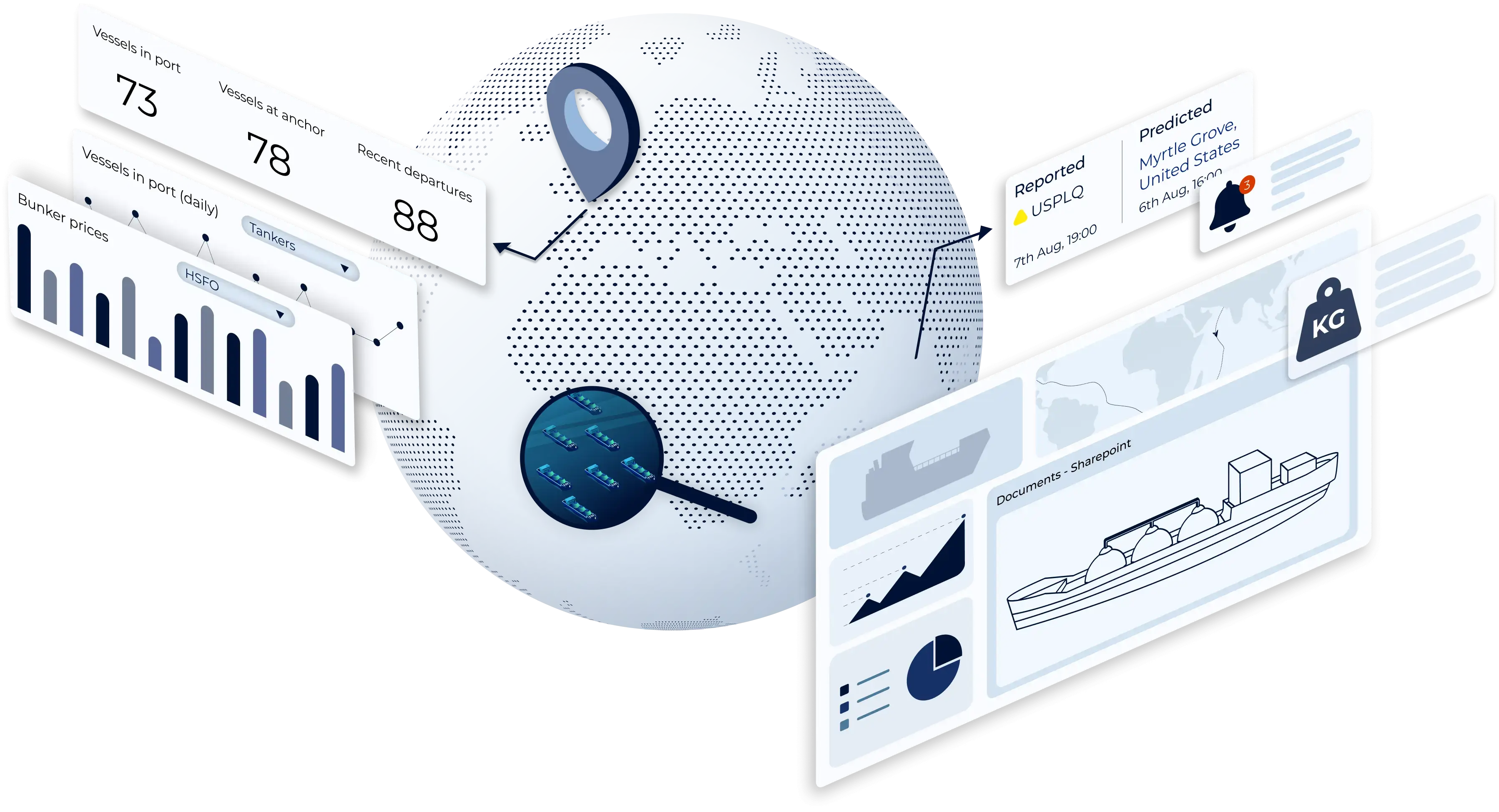


Create live vessel lists based on criteria such as; ballast/laden, current position, speed, course etc. and be notified about changes in real-time.
Learn more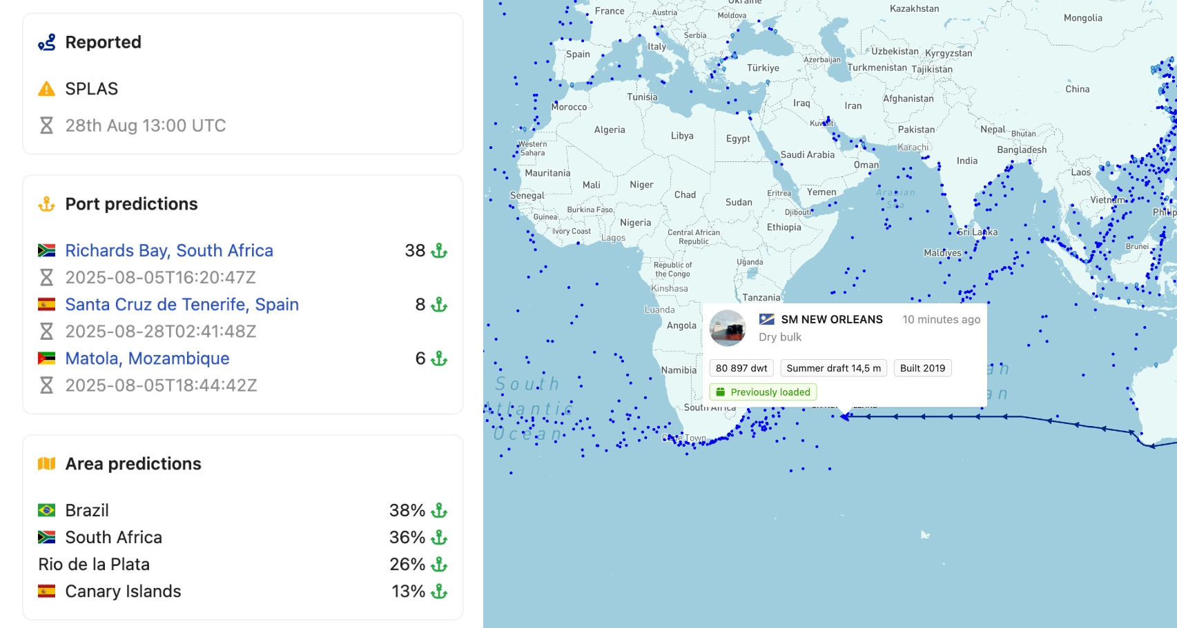
Find where where the vessels will sail when they say "unknown" or set a "not readable" destination.
Learn more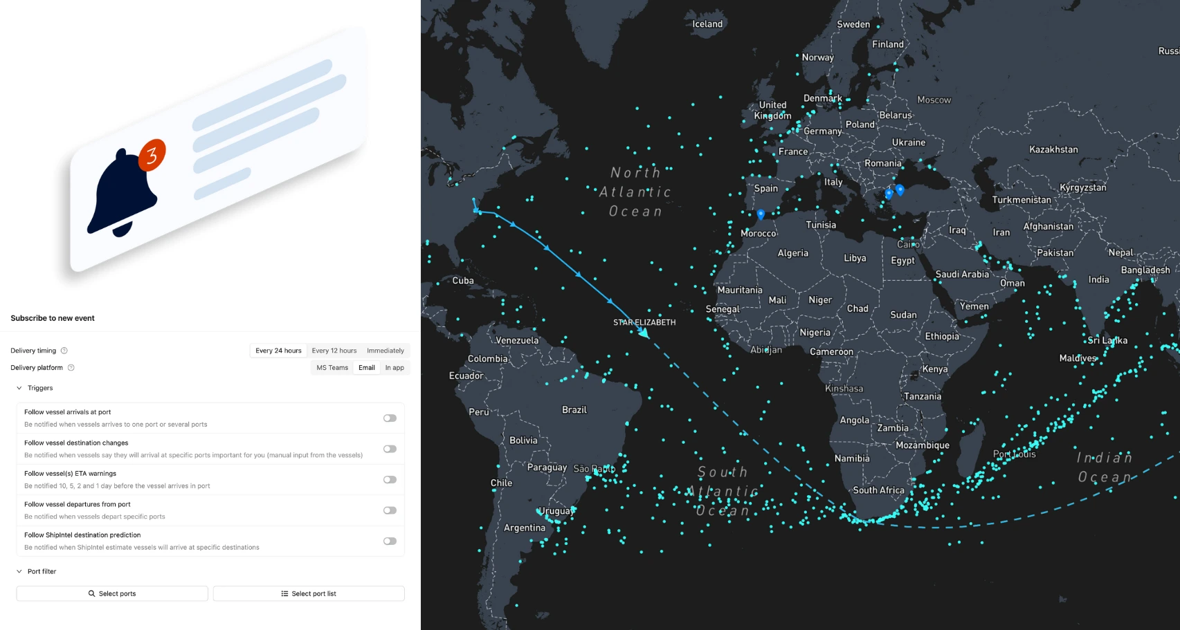
Be notified in real-time, daily email digests and in MS Teams, about vessel movements, port activity, and for chartering people; cargo statuses (Pre-fix).
Learn more
Access daily updated bunker prices and forward curves in bunkering ports.
Learn more
Find the shortest sea routes and compare alternative routes. Get distances, ETAs, calculated carbon emissions (EU ETS) and bunker consumption.
Learn more
ShipIntel can be seamlessly integrated with Microsoft 365 and your company's Microsoft Entra Access control system.
Learn moreMaritime Optima collects live raw AIS data from satellites, terrestrial and dynamic AIS sources enriched by other publicly available maritime data, and an in-house built sea route engine. We clean, unify, and process the data in-house to provide high-quality AIS data for all types of vessels with global coverage.
AI alone doesn’t create breakthroughs, but structured data and people do. Maritime Optima have developed a software that lets companies combine these high-quality maritime data with their proprietary data
By applying machine learning and deep learning analytics to these data sets; in real-time as well as for historicald ata, Maritime Optima offer companies involved in maritime business the next generation decision support software.
ShipIntel is available on the App Store and Google Play Store, allowing you to work on the go. You and your team's activity and data is automatically synced between your devices.


Explore ShipIntel through a live personalized demo where you ask the questions and we show you how to find the answers by using ShipIntel Essentials.

We decided to change over to ShipIntel because it is a great and user-friendly ship tracking system with so much more. With over 50 vessels in our ship project finance portfolio, we need ship details, alerts, port info, traffic statuses and trends all the time. ShipIntel is a tool that easily gives us such information and connects our team.

ShipIntel is our go-to solution for portfolio monitoring. ShipIntel is a reliable software built on high-quality data, followed by excellent customer and user service. Exactly what we need to gain real-time insight to empower our team's strategic decision-making.

Having used several competing AIS providers, we were confident in our decision to add ShipIntel Essentials to our toolbox. We are impressed with its sleek, responsive, and easy-to-use interface and we're excited to leverage its full potential in our day-to-day operations. Maritime Optima has been very attentive, listening to our needs and implementing functions we have requested.

We started using ShipIntel because we needed an AIS software and a sea route calculator. We added more features because we gained access to high-quality AIS data, smart AI searches, and a very user-friendly software at an affordable price. There are too many stand alone softwares, and we have started looking for a kind of all in one software that gives us what we need at an affordable price.
We chose ShipIntel because it is an innovative solution, easy to use, and comes with a very competitive price. We continued using ShipIntel because the Maritime Optima team continuously develop and maintain the software. We also think it is an advantage that maritime software is developed by people that have been working in the industry. So the easy to use, relevancy, high AIS quality and price makes ShipIntel a unique maritime software box.

We believe ShipIntel stands out on key points such as coverage, search/filters/lists, and user interface. The highly skilled IT team is supplemented with experienced shipping people, so we are confident that ShipIntel will continue developing to our benefit.

Create live vessel lists and be notified in real time, daily email digests or in Microsoft Teams, when the vessels arrive, depart or set a destination and later changes.
Find vessels in an area “just now” and find when they will be in a specific port or region.
Find vessels in ballast or laden condition able to meet a laycan window in a specific port and find the vessels ETAs.
Find vessels just left a port in laden or ballast condition with a set destination. Attached to each vessel in your list are technical descriptions, live AIS data, and port and berths the vessels have been visiting in the past.
Create as many live vessels lists as you want.
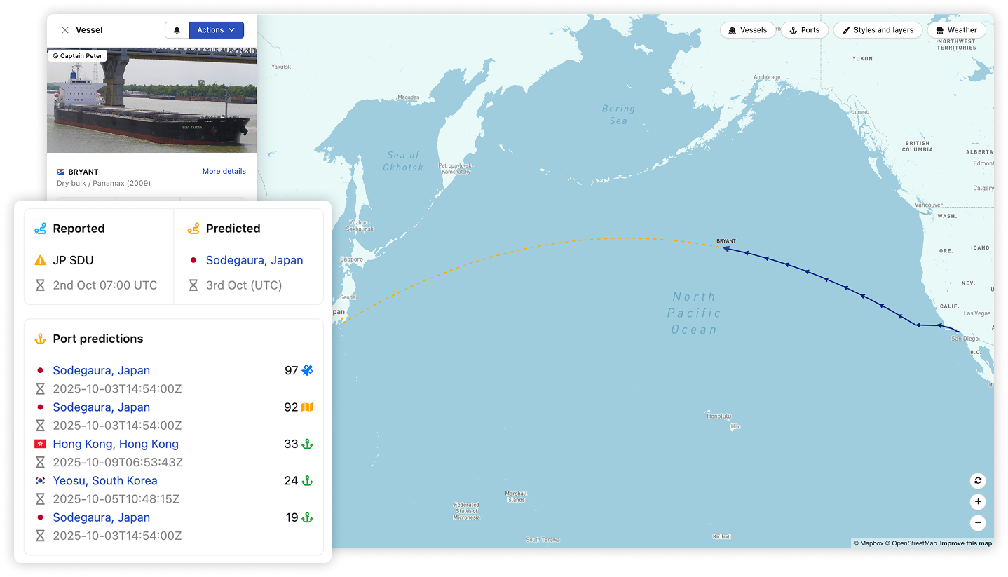
While some vessels set a destination, others don't. Therefore, ShipIntel have developed several predictive models which forecasts where the vessels will sail when they say "unknown" or set a "not readable" destination.
ShipIntel predicts the countries and the ports together with an ETA based on the vessel's AIS service speed.
If the vessel sets a destination with an ETA, we also show you what the vessel says so you can compare and evaluate.
Get notified in real time, daily email digests or in MS Teams about vessel movements, port activity, and cargo statuses.
Monitor vessels and ports and be notified when vessels set a destination or when ShipIntel predicts a destination (including ETAs and ETDs), when vessels are 10, 5 and 2 days away from arrival, or when they have arrived or departed any port.
Get alerts when vessels set and change speed, course, or status.
In Pre-fix, you can be notified about team progress and changes in cargo status (open, in calculation, in negotiation, fixed on subs, or fully fixed).


Find daily updated bunker prices in ports, historical data, short trends and forward curves for different bunker grades.
In the sea route calculator, you can find bunker ports along your sea-route and calculate fuel consumption and carbon emissions (EU ETS).
As a part of Pre-fix you can plan where to bunker and ShipIntel will notify you if and where you need to bunker, estimate the bunker intake and estimate the carbon emissions (EU ETS).
You can calculate sea routes from any of the vessel's real-time AIS positions to any port or combination of ports, or you can route between ports. ShipIntel warns if you try to route a vessel through a canal or strait if the vessel is too large to pass.
Avoid ice, minimize carbon emissions, avoid canals, shortest or alternative sea routes. Find the distance, ETA, and calculated carbon emissions (EU ETS).
The sea route calculator is excellent for user cases such as your vessel is on its way to Itaguai with an ETA 1st of March, and your broker asks if she can go to Port Kamsar instead and asks when she will be there. Or, if you are asked to give 3 new discharge options after you have fixed the vessel, where you have to give the ETA.
Integrate ShipIntel into your Microsoft 365 workspace:
